
Marine Protections: A Deep Dive
The Hauraki Gulf/Tikapa Moana Marine Protection Act has officially passed into law. Here's what you need to know


Now the Hauraki Gulf / Tikapa Marine Protection Act has officially passed into law, it's important we all have a good grasp on what the Protection Act is, why it's coming into effect, and what that means for us all.

Adam Whatton, Principal Ranger at the Department of Conservation, looks at what's happened, why it's happened, and what the future holds for the Hauraki Gulf.
What's the problem?
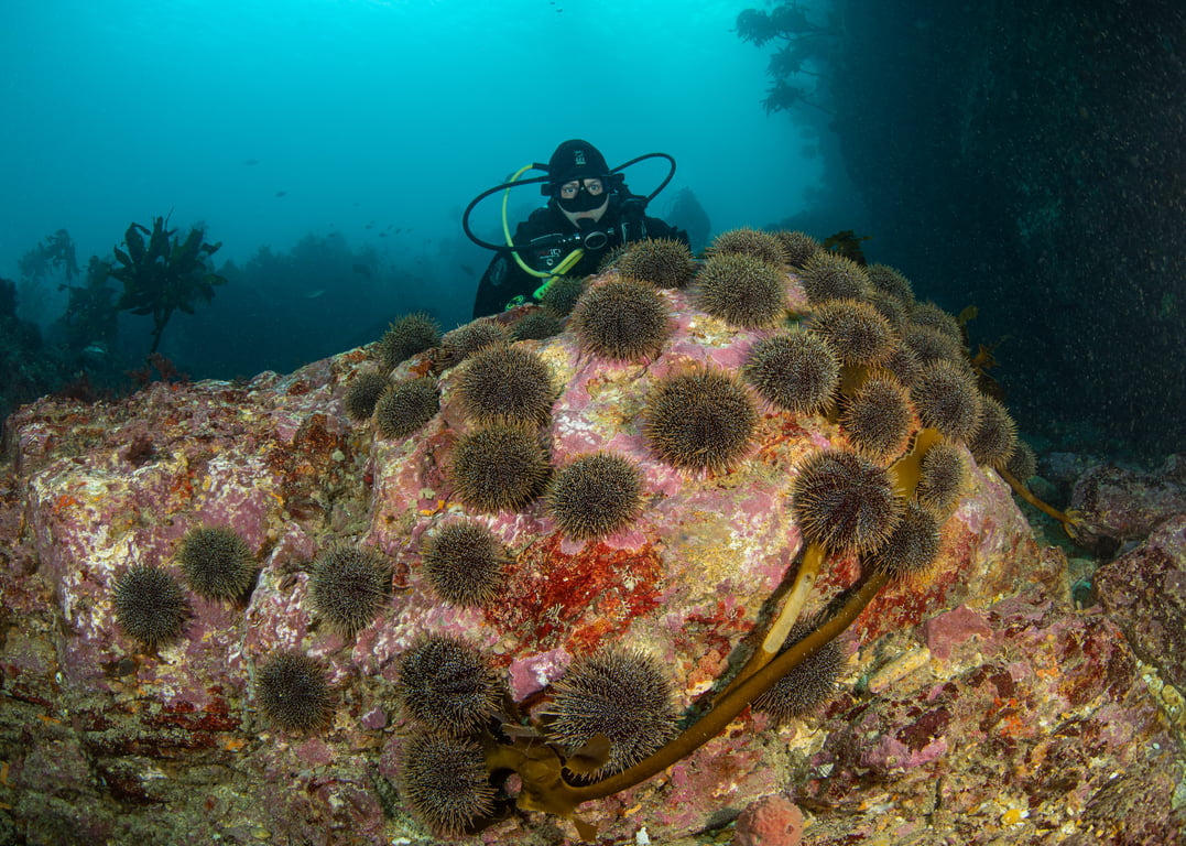
There’s no sugar-coating it — the Hauraki Gulf’s been doing it tough. Years of pollution, sediment washing in from the land, overfishing, and the growing impacts of climate change have taken their toll. We’re seeing more kina barrens popping up, precious habitats disappearing, and depleted shellfish beds throughout the area.
Yeah, that’s pretty bad.
To improve the Gulf environment, we need to manage human-made activities better on land and sea. What we’ve seen through monitoring we undertake in marine reserves around New Zealand is more types of fish and marine life, larger numbers and larger sizes. We’ve seen a spillover effect into the waters around.
So protection from human pressures like fishing, waste dumping and extraction in a productive marine ecosystem is one conservation-led way we can help improve the Gulf.
And yes, there are other ways to improve the health of the marine ecosystem, but let’s look at marine protection and how it can help.

What's the purpose of the Act?
The new act is more than a bit of a game changer – it’s the biggest boost to marine protection in Aotearoa more than a decade.
This law is all about focusing on key habitats where sea life breed and grow. The new network of protected areas safeguards rare and important habitats – the kinds acting as nurseries for young fish, to help rebuild fish size, abundance and variety
over time. The new protection tools – Seafloor Protection Areas and High Protection Areas - have built on what researchers have learnt from marine reserves.
These new areas are quite large which covers the movement of key species and helps them to be self-sustaining. The marine reserve at Goat Island/Te Hāwere-a-Maki has more than tripled in size, expanding out further away from the shore, and this now protects kōura/red rock lobster foraging into deeper water.
Many new protected areas are coming off the side of pest-free islands aka home base for seabirds that feed in the Hauraki Gulf. They also cover different types of habitats, like the now rare seagrass at Slipper Island or deeper rocky reefs, and
areas with useful water currents that encourage amazing marine life there. The Pakatoa and Tarahiki / Shag Island High Protection Area is a hammerhead shark nursery area and more than 77 types of shorebirds have been recorded there.
Here’s what’s included in the new protection network:
- Two expanded marine reserves, adding to the iconic Te Whanganui-o-Hei (Cathedral Cove) and Cape Rodney–Okakari Point (Goat Island) reserves.
- 12 High Protection Areas (HPAs)
- Five Seafloor Protection Areas (SPAs)
It’s a big step towards bringing the Gulf back to life, so future generations can enjoy clear waters, thriving sea life, and a healthy, resilient ecosystem.
High Protection Areas (HPAs)
These areas are all about protecting and restoring marine life by easing the pressure from human activity. In an HPA, you can still get out there and enjoy the water – swimming, kayaking, snorkelling, or anchoring your boat – but fishing and taking seafood are not permitted. Authorised customary fishing is allowed and there’s more explanation why below.
HPAs are like marine reserves, with more flexibility. Marine reserves were created for the purpose of 'scientific study of marine life'. Under that legislation, these areas must be fully left alone to nature - we’re not allowed to do anything to help areas, like you would when restoring the bush.
An HPA allows us to do active restoration to accelerate the restoration of a healthy ecosystem. This could be things like removing kina from barrens or reseeding shellfish beds. In fact, a philanthropic programme led by the NEXT Foundation has just committed $20 million towards reef restoration inside High Protection Areas. The focus is clearing urchins on barrens to help kelp regrow.
Kelp forests are one of the most productive habitats in the water, and will bring back fish, crayfish and shellfish. The
HPAs, which remove recreational and commercial fishing pressure, then allow species that eat urchins, such as kōura/red rock lobster, to thrive there and keep the ecosystem in balance.

What about commercial fishing in two of the HPAs?
There are limited exceptions in two of the 12 HPAs: Rangitoto and Motutapu HPA and Kawau HPA. Specific small-scale, authorised commercial fishing operators are allowed to conduct ring-net operations. They can only fish between 1 March to 31 August, and only target kahawai, trevally and/or grey mullet. The area they can fish in represents three percent of the total protected area under this act. This will be reviewed after three years.
What are 'customary fishing rights'?
Authorised customary fishing can take place in High Protection Areas. This recognises and supports Māori cultural knowledge, learning, and kaitiakitanga (guardianship) of the marine environment.
Customary fishing is not actually new; it is already authorised and regulated under Fisheries legislation. Customary non-
commercial rights are guaranteed under Te Tiriti o Waitangi and are managed under the Fisheries Act 1996.
In an HPA, customary fishing can only happen with written approval from a tangata kaitiaki/tiaki - local guardians who manage customary fishing within their rohe moana (area). The fishing can only be for a customary purpose, such as a hui (meeting) or tangi (funeral).
It’s worth noting that tangata whenua have been strong advocates for Tīkapa Moana/ Te Moananui-a-Toi. They have laid rāhui, backed up by fisheries closures, in areas where shellfish are struggling. They have taken action to restore shellfish beds including depositing green-lipped mussels in the Mahurangi Harbour and pāua around Waiheke Island. They have been invested in fighting the invasive caulerpa seaweed which smothers species beneath it.
The small amount of customary fishing occurring in the Gulf isn’t expected to affect the conservation goals of the high protection areas.
Are more HPAs likely in the Hauraki Gulf?
There are no current plans for new HPAs in the Hauraki Gulf and the Act does not provide for new HPAs to be established. For any new HPAs to be established this would require a change to the Act or new legislation.
Seafloor Protection Areas (SPAs)
SPAs focus on what’s happening on the seabed – protecting fragile seafloor habitats like sponge gardens and corals – and even sandy areas, where there’s more life than you might realise.
Recreational fishers can fish in a Seafloor Protection Area. You can still enjoy low-impact activities like line fishing, diving, surf-casting from the beach or gathering by hand, as long as you’re not disturbing the seafloor.
SPAs stop heavy-impact activities like bottom trawling or dredging, which can cause serious damage. It also limits things like sand-mining, drilling, aquaculture, and discharging sewage and waste.
In most of the Mokohīnau Islands SPA, a few extra rules apply – no set netting, potting, or bottom longlining – to make sure these unique underwater ecosystems with rare black corals stay intact.
Marine Reserves
You’re probably familiar. No fishing, collecting, or disturbing marine habitats is allowed here. Feeding fish, removing shells or rocks, or dumping waste is also off-limits. These areas are left completely untouched so that ecosystems can function without human interventions – good or bad – and researchers can study them.
How will I know about these areas?
The Department of Conservation is responsible for managing these areas, as they are a conservation measure. This law is brand new. It will take time for everyone to get familiar with the new boundaries and what they mean.
For now, our focus is on education and support. We’re heading to events, boat clubs, boats ramps and out on the water to chat about these new marine protections. We’re installing signage at boat ramps and entry points, distributing protection area maps to local businesses, and we’ve supplied digital maps to chart-plotter providers to update their mapping systems. The installation of more signs and marker buoys is currently being rolled out.
DOC’s compliance work will gradually build to support the education focus. This will include both on-the-water patrols, plus drones and high-zoom CCTV cameras to monitor activity in these protected areas.
Where can I find out more?
You can find the rules and an overview map on the DOC website, plus maps for each of the individual protection areas. There are also GPS files in GPX format to download and integrate into your GPS system.
www.doc.govt.nz/haurakigulfmarinepark
The free MarineMate App is being updated with the new rules and protection areas, so we recommend downloading this.
For a deeper dive into the where, what and why, head to the Department of Conservation website. On the Revitalising the Gulf page you can find links to the technical analysis - the science behind the new rules. You can also find information
on the background of these protections, from the Sea Change – Tai Timu Tai Pari Hauraki Gulf Marine Spatial Plan in 2017 to the final Act in place today.
Whether you’re a boatie, diver, fisher, or weekend explorer, it’s up to everyone to learn the new rules and play their part in protecting this incredible place. The real success of the Hauraki Gulf/Tīkapa Moana/Te Moananui-a-Toi will come
from what we all do next. Respect the rules, share them with your mates, and help give the Gulf the future it deserves.